San Juan River - Lower
NM
•
Tailwater
About San Juan River - Lower
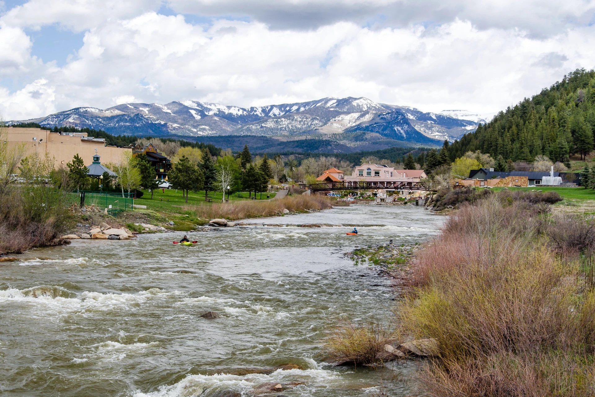
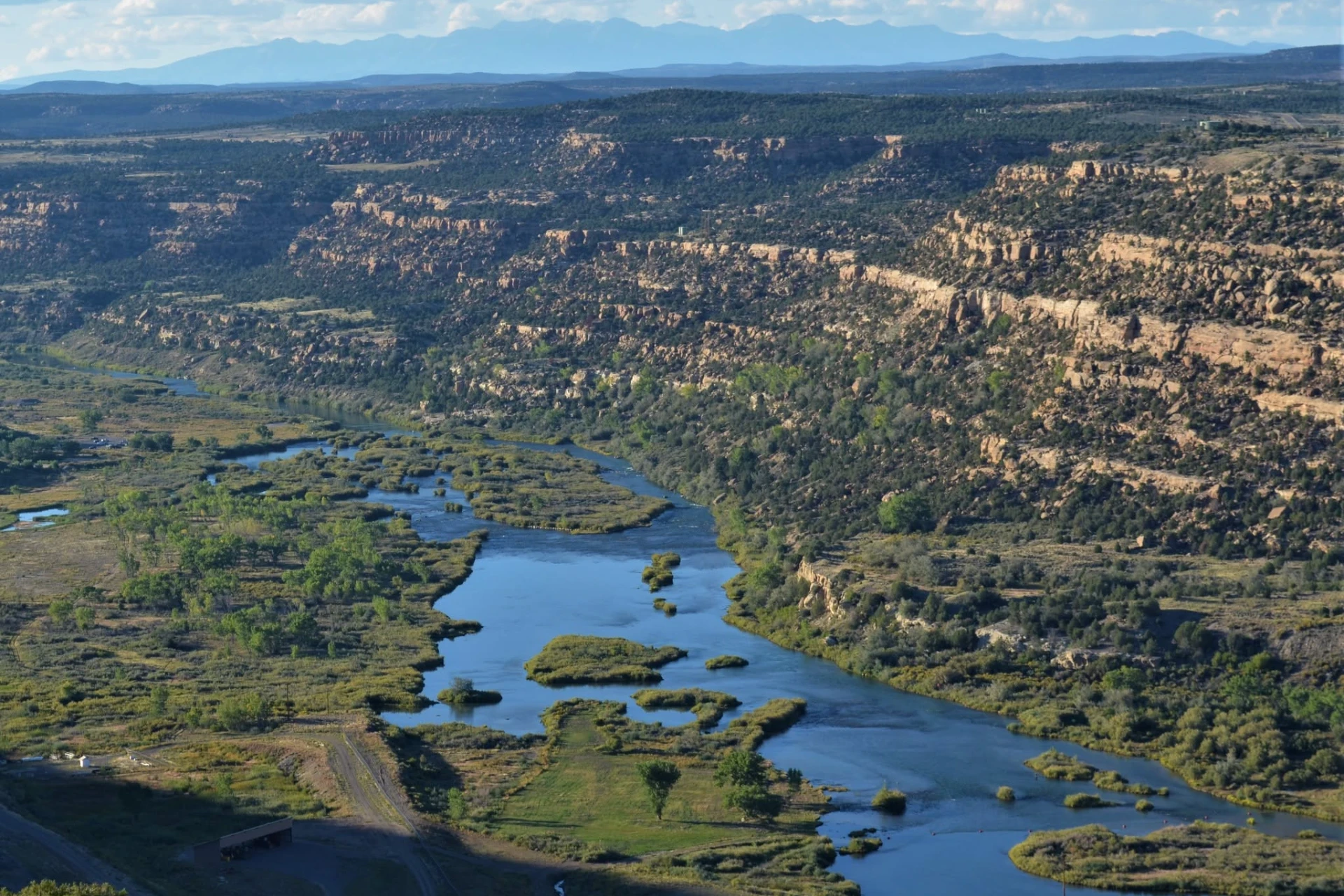
The San Juan River below Navajo Dam is a world-class tailwater fishery, offering consistent cold water through a high desert, shallow canyon. This river averages over 100 feet wide and presents a varied landscape for anglers, including broad flats, deep pools, runs, tailouts, eddies, and riffles. Access is straightforward, located 60 miles south of Durango, with public entry points stretching from Navajo Dam down to the Highway 173 bridge. The initial 3 3/4 miles directly below the dam are designated as Quality Water. Optimum flows for fishing range from 500 to 1000 cfs, with current conditions at 515 ft³/s and a water temperature of 51.98 °F. You'll find plenty of structure to work, from the deep holes created by current seams and eddies in areas like Texas Hole, to the long, slow, wadeable riffles of Cottonwood Flats and Walts Riffle further downstream. Rock structures and channel improvements in areas like Simon Canyon also provide additional fish cover and direct water flow. Anglers on the San Juan target abundant large rainbow and brown trout, known for being selective feeders. Year-round midge hatches are the most significant food source here. Beyond midges, look for blue-winged olive hatches, particularly in spring and fall, with insects typically in sizes 18-20. Pale morning dun hatches become important from early July through late September, with patterns in sizes 14-16. When fish are active on midges, effective fly patterns include various pupa, WD-40, and cluster patterns, ranging from size 14 down to 28. For subsurface work, Red Annelid, RS-2, and San Juan Worms in red, orange, tan, or brown are reliable. If you encounter fish taking emergers below the surface during a PMD hatch, use PMD emerger patterns. Texas Hole is the most popular fishery on the river, accessed from Highway 511 via a small paved road near a Catholic Church, about 1¼ miles below Navajo Dam. From the community of Navajo Dam, the turnoff is roughly 4.25 miles east of Float 'N Fish via Highways 173 and 511. The Navajo Lake State Park lot offers ample parking with a pay station and restrooms (no drinking water). Foot trails on the south bank lead downstream to Texas Hole (~300 yards) and upstream to Kiddie Hole and The Braids. Rainbows dominate, though wild Browns are present. Warmer water here supports a diverse insect population — Mayflies, Midges, Scuds, and Aquatic Worms. The top of Texas Hole features powerful runs from both banks, creating deep holes, current seams, and eddies. Below, water merges into a long, slow glide that's wadeable in many spots and popular with drift boat guides. Kiddie Hole — shallow, slow, and forgiving — has long been a go-to spot for teaching beginners. In late 2012, NM Game and Fish completed a major habitat improvement to The Braids and Kiddie Hole, adding flow diversions, channel structures, 21 dug holes for fish cover, and a siltation basin to manage runoff from Rex Smith Wash. The Lower River is fished by both bait and fly anglers. A parking lot sits on the east side just north of Aztec Bridge, where NM Game and Fish stocks catchable Rainbows. Wild Browns also spawn naturally here, including some large ones. An additional lot at the boat ramp downstream (via CR 4277 off NM 173) marks the lower boundary of public water — everything downstream is private. Water temps here support a rich insect mix: Midges, Mayflies, Golden Stoneflies, Caddis, and Aquatic Worms, with good dry-fly action when a hatch is on. Simon Canyon is accessible from both banks. The north-side trailhead is off County Road 4280, about 0.7 miles west of Float 'N Fish on Highway 173. Follow CR 4280 north and east for 3.1 miles (improved dirt) to the BLM parking area, which has a small restroom but no water or improved camping. From here, a ~3.5-mile footpath follows the north bank all the way to near the dam, accessing ET Rock, Death Row, Baetis Bend, the Lower Flats, Texas Hole, and the Cable Hole area — though steep cliffs make sections challenging. The water here is the warmest on the Quality Water stretch, with a diverse insect population including Caddis, Midges, Aquatic Worms, Mayflies, Scuds, and a few Golden Stoneflies. Notable water features include Cannon Run, Muskrat Row, Last Chance Riffle, and deep runs near Simon Canyon Wash and Duranglers Corner. NM Game and Fish has added rock structures throughout to improve habitat and channel flow. Both Browns and Rainbows are present. Cable Hole is primarily accessed from the south-bank parking area just downstream of the Bureau of Reclamation office — a Navajo Lake State Park lot with parking and a pay station (no restrooms or water). A steep 60-foot descent via switchbacks leads to the river, then a short trail (~¼ mile) heads upstream through marshy terrain. Near the river, trails continue downstream toward ESPN Hole, the Upper Flats, and Beaver Flats. The north bank is best reached by wading across in shallow areas at low flows (600 cfs or less). This is the coldest water on the Quality Water section, supporting large populations of Midges along with Scuds, Mayflies, and Aquatic Worms. Rainbows have historically dominated, though Browns are increasingly common, especially late in the season. From Cable Hole, anglers can fish upstream toward the dam or downstream through the Upper Flats to Beaver Flats. Cottonwood Campground is a full-service Navajo Lake State Park facility with RV hookups, improved campsites, multiple restrooms, day parking, and a pay station. From Float 'N Fish, go west on Highway 173 about ¼ mile past Aztec Bridge, then north on CR 4280 for 1.7 miles to the paved campground turnoff. The campground sits near river level for easy foot access. Quality Water ends just above Crusher Hole, so this stretch allows both bait and fly fishing with harvest permitted per NM Game and Fish regulations. Both Rainbows and wild Browns are present. Crusher Hole and the water above Cottonwood Flats offer deep, structure-heavy holding water for large fish; Cottonwood Flats and Walt's Riffle are long, slow, wadeable stretches. The warm water here supports a full insect menu — Mayflies, Caddis, Golden Stoneflies, Midges, Scuds, and Aquatic Worms.
Related reading

Conditions Report
Read tips and insights about recent conditions for San Juan River - Lower — gathered from on line sources.
Read the Conditions ReportAccess
Seasons
Terrain
Water
Fish Species
Rainbow Trout
Brown Trout
Regulations
•
Catch & Release: All fish must be immediately released. Handle with care using barbless hooks.
•
Artificial Lures Only: No natural bait permitted. Flies, lures, and artificial attractants only.
Fishing Styles
Water conditions
Water conditions for the last 7 days. You can gain insights to fishing activity based on these conditions, like water temperature and flow.
Data sourced from USGS National Water Information System
Methods
•
Wade Friendly
•
Float Friendly
Regulations
•
Catch & Release: All fish must be immediately released. Handle with care using barbless hooks.
•
Artificial Lures Only: No natural bait permitted. Flies, lures, and artificial attractants only.
Trip Planning
Best fishing typically occurs during year round. Check water conditions before heading out.
See what insects are emerging on San Juan River - Lower's hatch forecast — including active hatches, water temperatures, and which patterns to have in your box this month.